
1948 Map of Hartford
USGS Topo · Published 1948About this map
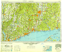
The Connecticut River valley anchors this detailed 1948 Army Map Service study, showing a region defined by its dense industrial corridors and coastal maritime hubs just after the war. The map documents the vital transportation networks of the era, from the New York New Haven and Hartford RR lines to the early modern engineering of the Merritt Parkway and Wilbur Cross Parkway. Major population centers like Hartford, New Haven, and Bridgeport are shown in high contrast against the surrounding terrain.
Find a feature on this map
85 named features on this map. Tap any name to fly to it.
Don’t see what you’re looking for? This feature index may not catch every label — zoom into the map to look around manually.
Map Details
Editions of this 1948 Hartford Map
2 editions found
Other maps of this area

1885 · Sheffield
USGS Topo · 1:62,500

1886 · Springfield
USGS Topo · 1:62,500

1887 · Brookfield
USGS Topo · 1:62,500

1887 · Palmer
USGS Topo · 1:62,500

1887 · Granville
USGS Topo · 1:62,500

1888 · Sheffield
USGS Topo · 1:62,500

1888 · Sandisfield
USGS Topo · 1:62,500

1888 · Paterson
USGS Topo · 1:62,500

1889 · Springfield
USGS Topo · 1:62,500

1889 · Stonington
USGS Topo · 1:62,500