
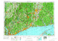
1965 Map of Hartford
USGS Topo · Published 1965About this map
Hartford and the industrial corridors of the Connecticut River valley anchor this mid-1960s regional portrait. The map documents the high-density urbanization along the Long Island Sound shoreline, from the western edge of Stamford through Bridgeport and New Haven. This era is defined by the rapid expansion of the modern highway system, featuring the Merritt Parkway, Wilbur Cross Parkway, and the New York State Thruway, which began to reshape the mobility patterns formerly dictated by the New York New Haven & Hartford RR. Inland, the map reveals the complex water infrastructure necessary for these growing centers, including the Barkhamsted Reservoir and Candlewood Lake. From the West Point Military Reservation on the Hudson River to the wooded expanse of Natchaug State Forest, the survey captures a New England landscape in transition between its manufacturing roots and its suburban future.
Find a feature on this map
108 named features on this map. Tap any name to fly to it.
Don’t see what you’re looking for? This feature index may not catch every label — zoom into the map to look around manually.
Map Details
Editions of this 1965 Hartford Map
2 editions found
Other maps of this area
1885 · Sheffield
USGS Topo · 1:62,500

1886 · Springfield
USGS Topo · 1:62,500

1887 · Brookfield
USGS Topo · 1:62,500

1887 · Palmer
USGS Topo · 1:62,500
1887 · Granville
USGS Topo · 1:62,500
1888 · Sheffield
USGS Topo · 1:62,500
1888 · Sandisfield
USGS Topo · 1:62,500

1888 · Paterson
USGS Topo · 1:62,500

1889 · Springfield
USGS Topo · 1:62,500
1889 · Stonington
USGS Topo · 1:62,500