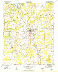
1951 Map of Hartselle
USGS Topo · Published 1951About this map
The town of Hartselle serves as the central hub of this 1951 survey, situated along the vital corridor of the Louisville and Nashville Railroad and the Bee Line Highway. This transport spine connects the agricultural uplands with the riverine landscape of the north, where the backwaters of Wheeler Reservoir reach into the Wheeler National Wildlife Refuge. The map details a transition from municipal development, including the Hartselle Water Supply and an Airfield, to a rural network of family-named crossings like Barkley Bridge and Nance Ford Bridge over Flint Creek. Numerous country churches and schools, such as Salem Ch and Collins Sch, are scattered throughout the quadrangle, illustrating the decentralized community structure of Morgan County at mid-century. To the east, the terrain rises toward Aiken Mtn, passing landmarks like the Natural Bridge and the Bethlehem Church near the county line.
Find a feature on this map
55 named features on this map. Tap any name to fly to it.
Don’t see what you’re looking for? This feature index may not catch every label — zoom into the map to look around manually.
Map Details
Editions of this 1951 Hartselle Map
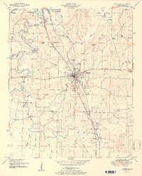
2 editions found
Other maps of this area

1888 · Cullman
USGS Topo · 1:125,000

1888 · Huntsville
USGS Topo · 1:125,000

1892 · Cullman
USGS Topo · 1:125,000

1892 · Huntsville
USGS Topo · 1:125,000

1927 · Falkville
USGS Topo · 1:24,000

1935 · Danville
USGS Topo · 1:48,000

1936 · Mc Kendry
USGS Topo · 1:24,000

1936 · Hartselle
USGS Topo · 1:24,000

1936 · Decatur
USGS Topo · 1:24,000

1936 · Trinity
USGS Topo · 1:24,000