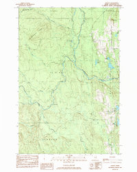
1984 Map of Harvey
USGS Topo · Published 1984About this map
The North Branch Meduxnekeag River snakes through the dense woodland of Aroostook County, defining a landscape of wetlands and ridges in the early 1980s. The small settlement at Harvey sits at a junction of backroads, including Wotton Road, while the community of Morey Brow occupies the western interior. This survey reveals a terrain shaped by glacial remnants, where numerous small bodies of water like Alberton Lake and Culling Pond are tucked between elevations such as Wellington Ridge and Sugar Loaf.
Find a feature on this map
35 named features on this map. Tap any name to fly to it.
Don’t see what you’re looking for? This feature index may not catch every label — zoom into the map to look around manually.
Map Details
Editions of this 1984 Harvey Map
This is the sole edition of this map. No revisions or reprints were ever made.
Other maps of this area

1934 · Bridgewater
USGS Topo · 1:48,000

1935 · Howe Brook
USGS Topo · 1:48,000

1937 · Smyrna Mills
USGS Topo · 1:62,500

1938 · Bridgewater
USGS Topo · 1:62,500

1938 · Houlton
USGS Topo · 1:62,500

1939 · Howe Brook
USGS Topo · 1:62,500

1951 · Houlton
USGS Topo · 1:62,500

1951 · Bridgewater
USGS Topo · 1:62,500

1953 · Bridgewater
USGS Topo · 1:50,000

1954 · Howe Brook
USGS Topo · 1:62,500