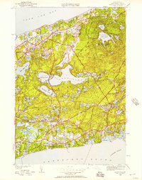
1949 Map of Harwich
USGS Topo · Published 1957About this map
Long Pond and a dense network of smaller freshwater kettles dominate this mid-century portrait of the Lower Cape, where the township boundaries of Brewster, Harwich, and Chatham converge. The landscape reflects a transition from traditional rail-side settlements like Pleasant Lake and South Brewster toward the recreational development of Nickerson State Park. The shoreline of Cape Cod Bay remains largely defined by its natural marshes and ponds, while the interior is punctuated by local landmarks like the Brewster School, the Brewster Church, and the New York New Haven and Hartford railroad line. Detailed surveying captures the early post-war residential patterns in coastal villages such as West Harwich and Harwich Port, providing a clear record of the area before the significant expansion of modern infrastructure.
Find a feature on this map
84 named features on this map. Tap any name to fly to it.
Don’t see what you’re looking for? This feature index may not catch every label — zoom into the map to look around manually.
Map Details
Editions of this 1949 Harwich Map
This is the sole edition of this map. No revisions or reprints were ever made.
Other maps of this area

1887 · Wellfleet
USGS Topo · 1:62,500

1887 · Yarmouth
USGS Topo · 1:62,500

1888 · Chatham
USGS Topo · 1:62,500

1889 · Yarmouth
USGS Topo · 1:62,500

1889 · Wellfleet
USGS Topo · 1:62,500

1893 · Chatham
USGS Topo · 1:62,500

1893 · Yarmouth
USGS Topo · 1:62,500

1893 · Wellfleet
USGS Topo · 1:62,500

1917 · Chatham
USGS Topo · 1:62,500

1942 · Cape Cod Bay
USGS Topo · 1:125,000