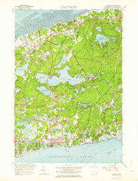
1961 Map of Harwich
USGS Topo · Published 1964About this map
The town of Harwich Port and the sprawling glacial lake system of the lower Cape define this landscape in the early 1960s. Coastal settlements from West Harwich to South Chatham show dense residential patterns along Nantucket Sound, contrasted with the interior's vast networks of Cranberry Bogs. The New York New Haven and Hartford railroad line cuts through the center of the sheet, linking Harwich to Pleasant Lake. To the north, the massive Long Pond and the wooded terrain of Nickerson State Park dominate the Brewster area. Significant local landmarks include the La Salette Seminary and the Brewster Country Club, alongside numerous family-named burial grounds like Evergreen Cem and Pine Grove Cem, which provide essential points of reference for local genealogists.
Find a feature on this map
120 named features on this map. Tap any name to fly to it.
Don’t see what you’re looking for? This feature index may not catch every label — zoom into the map to look around manually.
Map Details
Editions of this 1961 Harwich Map
2 editions found
Other maps of this area

1887 · Wellfleet
USGS Topo · 1:62,500

1887 · Yarmouth
USGS Topo · 1:62,500

1888 · Chatham
USGS Topo · 1:62,500

1889 · Yarmouth
USGS Topo · 1:62,500

1889 · Wellfleet
USGS Topo · 1:62,500

1893 · Chatham
USGS Topo · 1:62,500

1893 · Yarmouth
USGS Topo · 1:62,500

1893 · Wellfleet
USGS Topo · 1:62,500

1917 · Chatham
USGS Topo · 1:62,500

1942 · Cape Cod Bay
USGS Topo · 1:125,000