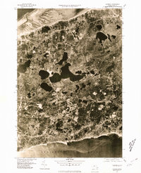
1977 Map of Harwich
USGS Topo · Published 1981About this map
Cape Cod narrows here between the northern waters of Cape Cod Bay and the southern reaches of Nantucket Sound. This 1977 orthophotoquad provides a literal photographic record of the landscape, capturing the dense cluster of mid-century residential development and the intricate network of glacial kettle ponds that define this section of the peninsula. Long Pond dominates the central interior, acting as a massive natural anchor between the inland village of Brewster and the more densely settled coastal centers. Along the southern shore, the high-contrast imagery reveals the precise layout of Harwich Port and Dennis Port, where the winding course of the Herring River flows toward the sound. Genealogists and historians can use this aerial perspective to study the established patterns of Harwich and South Chatham before decades of later expansion altered the local tree cover and property lines.
Find a feature on this map
11 named features on this map. Tap any name to fly to it.
Don’t see what you’re looking for? This feature index may not catch every label — zoom into the map to look around manually.
Map Details
Editions of this 1977 Harwich Map
This is the sole edition of this map. No revisions or reprints were ever made.
Other maps of this area

1887 · Wellfleet
USGS Topo · 1:62,500

1887 · Yarmouth
USGS Topo · 1:62,500

1888 · Chatham
USGS Topo · 1:62,500

1889 · Yarmouth
USGS Topo · 1:62,500

1889 · Wellfleet
USGS Topo · 1:62,500

1893 · Chatham
USGS Topo · 1:62,500

1893 · Yarmouth
USGS Topo · 1:62,500

1893 · Wellfleet
USGS Topo · 1:62,500

1917 · Chatham
USGS Topo · 1:62,500

1942 · Cape Cod Bay
USGS Topo · 1:125,000