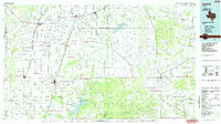
1985 Map of Haskell
USGS Topo · Published 1985About this map
The Brazos River and its numerous forks define this West Texas landscape, where agriculture and petroleum production dominate the economy in the mid-1980s. The regional centers of Haskell and Throckmorton serve as hubs for a network of farm roads and highways, including US Highway 277 and US Highway 380. For genealogists, the map identifies local landmarks like the Throckmorton Cem and outlying settlements such as O'Brien, Rochester, and Goree.
Find a feature on this map
66 named features on this map. Tap any name to fly to it.
Don’t see what you’re looking for? This feature index may not catch every label — zoom into the map to look around manually.
Map Details
Editions of this 1985 Haskell Map
2 editions found
Other maps of this area

1890 · Breckenridge
USGS Topo · 1:125,000

1891 · Anson
USGS Topo · 1:125,000

1892 · Albany
USGS Topo · 1:125,000

1893 · Albany
USGS Topo · 1:125,000

1893 · Roby
USGS Topo · 1:125,000

1893 · Anson
USGS Topo · 1:125,000

1925 · Aspermont 4-a
USGS Topo · 1:48,000

1925 · Haskell 3-b
USGS Topo · 1:48,000

1931 · Aspermont
USGS Topo · 1:62,500

1932 · Dundee
USGS Topo · 1:62,500