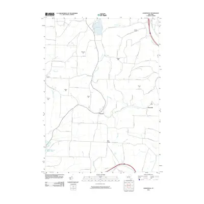
2010 Map of Haskinville
USGS Topo · Published 2010About this map
Haskinville and the surrounding Steuben County uplands are defined by a high-elevation landscape of named summits and creek valleys. This 2010 survey illustrates a rural settlement pattern where clusters like Greenville and Jobs Corner serve as anchors among the hills. The terrain is notably dissected by watercourses such as Neils Creek, Page Brook, and the Cohocton River, which have shaped the local road network and agricultural layout. Significant local water bodies including Loon Lake and Mud Lake sit in the northern reaches, while the Hornell Reservoir Number Three occupies the southwest corner. Genealogists and local historians can locate the Beachville Cemetery on the western edge of the map, situated between Cream Hill and Bronson Hill. The naming of features like Potter Hill, Maple Hill, and Oil Well Hollow reflects the region's long history of family-based landholding and resource extraction in the Finger Lakes region.
Find a feature on this map
89 named features on this map. Tap any name to fly to it.
Don’t see what you’re looking for? This feature index may not catch every label — zoom into the map to look around manually.
Map Details
Editions of this 2010 Haskinville Map
This is the sole edition of this map. No revisions or reprints were ever made.
Other maps of this area

1900 · Naples
USGS Topo · 1:62,500

1902 · Wayland
USGS Topo · 1:62,500

1903 · Naples
USGS Topo · 1:62,500

1904 · Wayland
USGS Topo · 1:62,500

1910 · Bath
USGS Topo · 1:62,500

1913 · Naples
USGS Topo · 1:62,500

1915 · Hornell
USGS Topo · 1:62,500

1918 · Hornell
USGS Topo · 1:62,500

1942 · Wayland
USGS Topo · 1:31,680

1942 · Naples
USGS Topo · 1:31,680