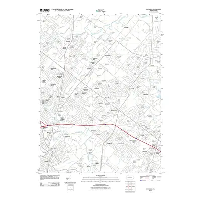
2010 Map of Hatboro
USGS Topo · Published 2010About this map
Little Neshaminy Creek and Neshaminy Creek define the northern drainage of this suburban landscape, where historic agricultural land increasingly gave way to residential developments. The area preserves significant local history through its many burial grounds, including the Neshaminy Cemetery and the more contemporary Shalom Memorial Cemetery. Traces of early industry remain at Stover Mill and near the Paper Mills along Pennypack Creek. Educational and military footprints are notable at Log College and the Warminster NADC Airport. The map shows a transition from estate-like properties such as Saxony Manor and Grenoble Manor to dense post-war housing and infrastructure like the Pennsylvania Turnpike Interchange 21. These layers of development reflect the expansion of the northern Philadelphia suburbs through the mid-20th century.
Find a feature on this map
212 named features on this map. Tap any name to fly to it.
Don’t see what you’re looking for? This feature index may not catch every label — zoom into the map to look around manually.
Map Details
Editions of this 2010 Hatboro Map
This is the sole edition of this map. No revisions or reprints were ever made.
Other maps of this area

1890 · Lambertville
USGS Topo · 1:62,500

1890 · Doylestown
USGS Topo · 1:62,500

1890 · Burlington
USGS Topo · 1:62,500

1891 · Lambertville
USGS Topo · 1:62,500

1891 · Doylestown
USGS Topo · 1:62,500

1893 · Germantown
USGS Topo · 1:62,500

1893 · Burlington
USGS Topo · 1:62,500

1894 · Lambertville
USGS Topo · 1:62,500

1894 · Germantown
USGS Topo · 1:62,500

1896 · Germantown
USGS Topo · 1:62,500
Featured Places
- Philadelphia, PA
- Abington Township, PA
- Warminster Township, PA
- Horsham Township, PA
- Warrington Township, PA