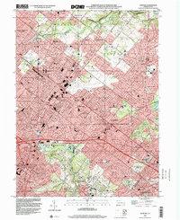
1999 Map of Hatboro
USGS Topo · Published 2001About this map
Bryn Athyn and the surrounding townships in Montgomery and Bucks counties appear here during a period of dense suburbanization at the close of the twentieth century. The landscape is defined by a heavy concentration of residential developments like Warminster Village, Rosewood Park, and Casey Highlands, which have filled the spaces between older centers like Hatboro and Willow Grove. This transition from rural holdings to a structured suburban grid is underscored by the extensive network of local schools, including the Archbishop Wood High Schs and Tennent High Sch, which serve the burgeoning population.
Find a feature on this map
79 named features on this map. Tap any name to fly to it.
Don’t see what you’re looking for? This feature index may not catch every label — zoom into the map to look around manually.
Map Details
Editions of this 1999 Hatboro Map
This is the sole edition of this map. No revisions or reprints were ever made.
Other maps of this area

1890 · Lambertville
USGS Topo · 1:62,500

1890 · Doylestown
USGS Topo · 1:62,500

1890 · Burlington
USGS Topo · 1:62,500

1891 · Lambertville
USGS Topo · 1:62,500

1891 · Doylestown
USGS Topo · 1:62,500

1893 · Germantown
USGS Topo · 1:62,500

1893 · Burlington
USGS Topo · 1:62,500

1894 · Lambertville
USGS Topo · 1:62,500

1894 · Germantown
USGS Topo · 1:62,500

1896 · Germantown
USGS Topo · 1:62,500
Featured Places
- Philadelphia, PA
- Abington Township, PA
- Warminster Township, PA
- Horsham Township, PA
- Warrington Township, PA