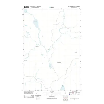
2011 Map of Hay Brook Mountain
USGS Topo · Published 2011About this map
Seboeis River drainage dominates this section of the Maine North Woods, where water and topography dictate the movement through the landscape. The river flows south past Snowshoe Lake and White Horse Lake, joined by numerous tributaries like Hobart Brook and Flemming Brook. This 2011 survey documents a sparsely populated region primarily utilized for forestry and recreation, as evidenced by the Seboeis River Wilderness Camp and Hay Brook Farm. Notable topographic landmarks like Hay Brook Mountain and Roberts Mountain rise above a complex network of ponds and brooks, including the distinctive Godfrey Pitch and Shin Falls. Transportation in this interior region is limited to local routes such as Grand Lake Rd and Snowshoe Lake Rd, which provide access to the hunting and fishing camps scattered throughout the watershed.
Find a feature on this map
24 named features on this map. Tap any name to fly to it.
Don’t see what you’re looking for? This feature index may not catch every label — zoom into the map to look around manually.
Map Details
Editions of this 2011 Hay Brook Mountain Map
This is the sole edition of this map. No revisions or reprints were ever made.
Other maps of this area

1940 · Island Falls
USGS Topo · 1:62,500

1940 · Oxbow
USGS Topo · 1:62,500

1942 · Island Falls
USGS Topo · 1:62,500

1942 · Oxbow
USGS Topo · 1:62,500

1954 · Shin Pond
USGS Topo · 1:62,500

1954 · Grand Lake Seboeis
USGS Topo · 1:62,500

1954 · Presque Isle
USGS Topo · 1:250,000

1958 · Presque Isle
USGS Topo · 1:250,000

1960 · Presque Isle
USGS Topo · 1:250,000
1965 · Oxbow
USGS Topo · 1:62,500