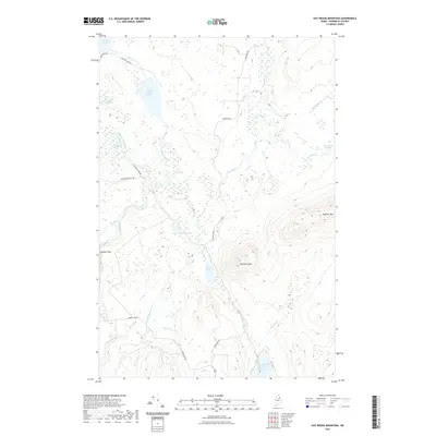
2021 Map of Hay Brook Mountain
USGS Topo · Published 2021About this map
Seboeis River drainage patterns and the complex wetlands of Penobscot County define this northern landscape. The terrain is anchored by significant elevations at Hay Brook Mtn and Roberts Mtn, which overlook a network of lakes and ponds including White Horse Lake, Hot Pond, and the northern edge of Upper Shin Pond. The water systems here feature distinct navigational markers like Tiger Rips and Godfrey Pitch, while the extensive Lane Brook Meadows indicate the seasonally shifting nature of the local hydrography.
Find a feature on this map
25 named features on this map. Tap any name to fly to it.
Don’t see what you’re looking for? This feature index may not catch every label — zoom into the map to look around manually.
Map Details
Editions of this 2021 Hay Brook Mountain Map
This is the sole edition of this map. No revisions or reprints were ever made.
Other maps of this area

1940 · Island Falls
USGS Topo · 1:62,500

1940 · Oxbow
USGS Topo · 1:62,500

1942 · Island Falls
USGS Topo · 1:62,500

1942 · Oxbow
USGS Topo · 1:62,500

1954 · Shin Pond
USGS Topo · 1:62,500

1954 · Grand Lake Seboeis
USGS Topo · 1:62,500

1954 · Presque Isle
USGS Topo · 1:250,000

1958 · Presque Isle
USGS Topo · 1:250,000

1960 · Presque Isle
USGS Topo · 1:250,000
1965 · Oxbow
USGS Topo · 1:62,500