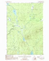
1986 Map of Hay Brook Mtn
USGS Topo · Published 1986About this map
The Seboeis River defines the landscape of this Penobscot County interior, winding through a series of tranquil deadwaters and dramatic elevation changes. The Upper Seboeis River Gorge and Tiger Rips showcase the river's more volatile stretches, contrasting with the slow-moving Seboeis Deadwater and Hobart Deadwater. Human presence in this timber-rich region is localized at Hay Brook Farm and the Seboeis River Wilderness Camp, illustrating the area's role as a base for seasonal residency and woods work.
Find a feature on this map
30 named features on this map. Tap any name to fly to it.
Don’t see what you’re looking for? This feature index may not catch every label — zoom into the map to look around manually.
Map Details
Editions of this 1986 Hay Brook Mtn Map
This is the sole edition of this map. No revisions or reprints were ever made.
Other maps of this area

1940 · Island Falls
USGS Topo · 1:62,500

1940 · Oxbow
USGS Topo · 1:62,500

1942 · Island Falls
USGS Topo · 1:62,500

1942 · Oxbow
USGS Topo · 1:62,500

1954 · Shin Pond
USGS Topo · 1:62,500

1954 · Grand Lake Seboeis
USGS Topo · 1:62,500

1954 · Presque Isle
USGS Topo · 1:250,000

1958 · Presque Isle
USGS Topo · 1:250,000

1960 · Presque Isle
USGS Topo · 1:250,000
1965 · Oxbow
USGS Topo · 1:62,500