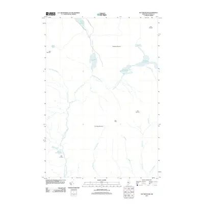
2011 Map of Hay Mountain
USGS Topo · Published 2011About this map
The West Branch Pleasant River winds through this heavily wooded corridor of the Maine North Woods, a landscape defined by its remote chain of lakes and high ridges. The Little Lyford Pond Camps are situated near the Little Lyford Ponds, marking a rare point of human infrastructure in an area otherwise dominated by physical geography. The topography rises sharply to landmarks such as Gulf Hagas Mountain and the prominent Hay Mountain, which provides a natural backdrop to the numerous drainages including Gulf Hagas Brook and White Brook. To the north, the waters of First Roach Pond and Big Lyford Pond anchor a complex hydrography that has long supported the regional timber and recreation economies. Transportation is limited to functional backcountry routes like Frenchtown Rd and Shaw Mountain Rd, which provide access to this interior segment of Piscataquis County.
Find a feature on this map
23 named features on this map. Tap any name to fly to it.
Don’t see what you’re looking for? This feature index may not catch every label — zoom into the map to look around manually.
Map Details
Editions of this 2011 Hay Mountain Map
This is the sole edition of this map. No revisions or reprints were ever made.
Other maps of this area

1940 · Sebec
USGS Topo · 1:48,000

1943 · Sebec
USGS Topo · 1:62,500

1950 · Sebec Lake
USGS Topo · 1:62,500

1952 · Jo-Mary Mountain
USGS Topo · 1:62,500

1952 · First Roach Pond
USGS Topo · 1:62,500

1954 · Millinocket
USGS Topo · 1:250,000

1958 · Millinocket
USGS Topo · 1:250,000

1960 · Millinocket
USGS Topo · 1:250,000
1977 · Number Four Mountain
USGS Topo · 1:24,000
1977 · Barren Mountain West
USGS Topo · 1:24,000
Featured Places
- Beaver Cove, ME
- Frenchtown Township, ME
- Shawtown Township, ME
- Bowdoin College Grant East Township, ME
- Bowdoin College Grant West Township, ME