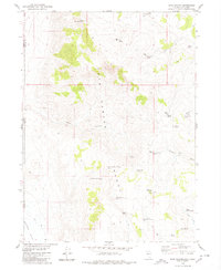
1979 Map of Hays Canyon
USGS Topo · Published 1980About this map
Hays Canyon Range dominates this landscape along the Nevada-California border, revealing a network of remote springs and high peaks that defined movement through this high-desert territory. The survey identifies vital water sources for ranching and travel, from Pick And Shovel Springs No 1 and its companion Pick And Shovel Spring No 2 to the centrally located Indian Pole Camp. The placement of features like Devils Gate and Divine Peak illustrates the natural corridors used to navigate the terrain between Surprise Valley and the interior basins. In the southern portion of the sheet, Indian Valley contains a cluster of hydrologic points including Lower Indian Spring and Upper Indian Springs, indicating a concentration of resource value in an otherwise arid region. Primitive transit is evidenced by numerous jeep trails and the presence of the Lund settlement site at the southwestern edge.
Find a feature on this map
33 named features on this map. Tap any name to fly to it.
Don’t see what you’re looking for? This feature index may not catch every label — zoom into the map to look around manually.
Map Details
Editions of this 1979 Hays Canyon Map
This is the sole edition of this map. No revisions or reprints were ever made.
Other maps of this area

1886 · Alturas
USGS Topo · 1:250,000

1889 · Long Valley
USGS Topo · 1:250,000

1892 · Alturas
USGS Topo · 1:250,000

1954 · Vya
USGS Topo · 1:250,000

1954 · Alturas
USGS Topo · 1:250,000

1958 · Alturas
USGS Topo · 1:250,000

1958 · Vya
USGS Topo · 1:250,000

1962 · Alturas
USGS Topo · 1:250,000

1962 · Vya
USGS Topo · 1:250,000

1962 · Snake Lake
USGS Topo · 1:24,000