
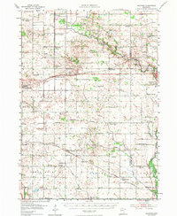
1954 Map of Hayward
USGS Topo · Published 1956About this map
The Chicago Milwaukee St Paul and Pacific and Illinois Central railroads define the development of southern Freeborn County on the border of Minnesota Iowa. Small rural centers such as Hayward, Myrtle, and London are surrounded by a dense network of country schoolhouses, including the Moucha Sch, Lao Sch, and Deveraux Sch, which anchored the farming communities of the mid-1950s. The landscape is marked by unique cultural markers like the Trondhjem Ch, Bohemian Cem, and Danish Cem, reflecting the Scandinavian and European heritage of the region's settlers. Along the eastern edge, the growth of Austin is evident near the Cedar River, while the southern reaches feature the meandering Deer Creek and the marshy expanses of Mud Lake. This survey captures a moment when traditional agrarian patterns, evidenced by numerous named family-centered landmarks like Sigsbee and Twin Grove, remained fully intact.
Find a feature on this map
80 named features on this map. Tap any name to fly to it.
Don’t see what you’re looking for? This feature index may not catch every label — zoom into the map to look around manually.
Map Details
Editions of this 1954 Hayward Map
2 editions found
Other maps of this area

1954 · Albert Lea
USGS Topo · 1:62,500

1954 · Austin
USGS Topo · 1:62,500

1954 · Mason City
USGS Topo · 1:250,000

1957 · Mason City
USGS Topo · 1:250,000

1958 · Mason City
USGS Topo · 1:250,000

1966 · Waltham
USGS Topo · 1:24,000

1967 · Blooming Prairie
USGS Topo · 1:24,000

1967 · Hollandale
USGS Topo · 1:24,000

1967 · Ellendale
USGS Topo · 1:24,000

1972 · St. Ansgar
USGS Topo · 1:24,000