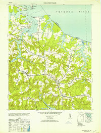
1953 Map of Heathsville
USGS Topo · Published 1953About this map
Heathsville serves as the central hub of this Northern Neck landscape, where the tidal fingers of the Potomac River meet the agricultural heart of Northumberland County. The map reveals a community defined by its proximity to the water, from the northern docks at Lewisetta and Cowart to the landings at Forrest Ldg and Rowes Ldg along the Coan River. Inland, the settlement pattern is marked by family-named crossroads and centers of worship such as St Stephens Ch and Smithland Ch.
Find a feature on this map
70 named features on this map. Tap any name to fly to it.
Don’t see what you’re looking for? This feature index may not catch every label — zoom into the map to look around manually.
Map Details
Editions of this 1953 Heathsville Map
This is the sole edition of this map. No revisions or reprints were ever made.
Other maps of this area

1892 · Piney Point
USGS Topo · 1:62,500

1894 · Piney Point
USGS Topo · 1:62,500

1894 · Point Lookout
USGS Topo · 1:62,500

1895 · Nomini
USGS Topo · 1:125,000

1895 · Piney Point
USGS Topo · 1:62,500

1898 · Nomini
USGS Topo · 1:125,000

1898 · St. Marys
USGS Topo · 1:125,000

1901 · Piney Point
USGS Topo · 1:62,500

1906 · St. Marys
USGS Topo · 1:125,000

1912 · Point Lookout
USGS Topo · 1:62,500