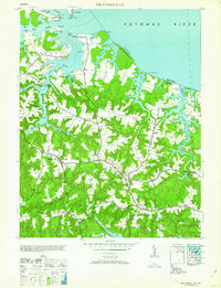
1962 Map of Heathsville
USGS Topo · Published 1962About this map
Heathsville serves as the focal point of this Northern Neck peninsula, where the inland agricultural landscape meets the intricate tidewater system of the Potomac River and Great Wicomico River. The 1940s field data captured here reveals a deeply interconnected coastal economy defined by numerous landings and small settlements. Along the waterfront, points like Lewisetta and Bundick emphasize the importance of water access, while inland, a network of family-named corners such as Hamlins Corner and Downings Corner points to a landscape of established family farms. The map documents vital community centers including St Stephens Ch and the Avalon Sch, alongside remnant industrial sites like Crabbe Mill and Sydnors Mill. The physical geography is dominated by distinct peninsulas known as necks, including Bay Quarter Neck and Neuman Neck, which separate the various creeks and ponds that feed into the larger river systems.
Find a feature on this map
64 named features on this map. Tap any name to fly to it.
Don’t see what you’re looking for? This feature index may not catch every label — zoom into the map to look around manually.
Map Details
Editions of this 1962 Heathsville Map
This is the sole edition of this map. No revisions or reprints were ever made.
Other maps of this area

1892 · Piney Point
USGS Topo · 1:62,500

1894 · Piney Point
USGS Topo · 1:62,500

1894 · Point Lookout
USGS Topo · 1:62,500

1895 · Nomini
USGS Topo · 1:125,000

1895 · Piney Point
USGS Topo · 1:62,500

1898 · Nomini
USGS Topo · 1:125,000

1898 · St. Marys
USGS Topo · 1:125,000

1901 · Piney Point
USGS Topo · 1:62,500

1906 · St. Marys
USGS Topo · 1:125,000

1912 · Point Lookout
USGS Topo · 1:62,500