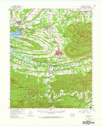
1959 Map of Heavener
USGS Topo · Published 1966About this map
The Poteau River valley serves as a primary corridor for transportation and settlement in this late 1950s survey of eastern Oklahoma. The city of Heavener stands at a significant junction where the Kansas City Southern railroad intersects the rugged slopes of Poteau Mountain. This rail-oriented economy is further evidenced by the Chicago Rock Island and Pacific lines moving through Wister and Howe. Outside the industrial and transit hubs, the landscape transitions into the protected wilderness of the Ouachita National Forest. Local history is preserved in rural landmarks such as Mt Pleasant Ch, the Hodgen Cem near Hodgens, and the small community of Monroe near the northern border. Significant water features like Lake Wister and Hontubby Falls highlight the importance of the region's watersheds to both local industry and early recreational development at Lake Wister State Park.
Find a feature on this map
98 named features on this map. Tap any name to fly to it.
Don’t see what you’re looking for? This feature index may not catch every label — zoom into the map to look around manually.
Map Details
Editions of this 1959 Heavener Map
2 editions found

Other maps of this area

1887 · Poteau Mountain #2
USGS Topo · 1:62,500

1887 · Greenwood
USGS Topo · 1:62,500

1890 · Fort Smith
USGS Topo · 1:125,000

1890 · Poteau Mountain
USGS Topo · 1:125,000

1899 · Poteau Mountain
USGS Topo · 1:125,000

1900 · Sallisaw
USGS Topo · 1:125,000

1900 · Winding Stair
USGS Topo · 1:125,000

1909 · Winding Stair
USGS Topo · 1:125,000

1911 · Sallisaw
USGS Topo · 1:125,000

1943 · Fort Smith
USGS Topo · 1:125,000