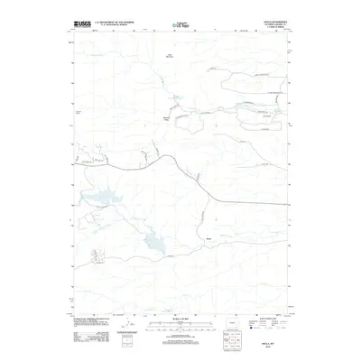
2012 Map of Hecla
USGS Topo · Published 2012About this map
Hecla sits at the heart of a high-altitude drainage basin defined by a complex network of water management features in the Laramie County foothills. The landscape is dominated by multiple reservoirs that capture the flow of N Fork Crow Cr and Middle Crow Cr, including the significant Granite Springs Reservoir and Crystal Lake Reservoir. This area reflects a legacy of ranching and irrigation, evidenced by established holdings like McIntyre Ranch and Merritt Ranch, along with specialized infrastructure such as the Whitney Ditch and the North Crow Diversion Reservoir. High points like Table Mountain provide a rugged backdrop to the local road network, which transitions from named loops like N Table Mountain Loop to smaller residential lanes like Tomahawk Rd and Wagon Trail Dr.
Find a feature on this map
41 named features on this map. Tap any name to fly to it.
Don’t see what you’re looking for? This feature index may not catch every label — zoom into the map to look around manually.
Map Details
Editions of this 2012 Hecla Map
This is the sole edition of this map. No revisions or reprints were ever made.
Other maps of this area

1905 · Sherman
USGS Topo · 1:125,000

1948 · Sherman Mountains
USGS Topo · 1:62,500

1948 · Ragged Top Mountain
USGS Topo · 1:62,500

1950 · Ragged Top Mountain
USGS Topo · 1:62,500

1950 · Sherman Mountains
USGS Topo · 1:62,500

1954 · Cheyenne
USGS Topo · 1:250,000

1958 · Cheyenne
USGS Topo · 1:250,000

1962 · Federal
USGS Topo · 1:24,000
1962 · Silver Crown
USGS Topo · 1:24,000
1962 · Hecla
USGS Topo · 1:24,000