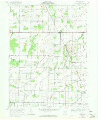
1969 Map of Helena
USGS Topo · Published 1971About this map
The village of Helena serves as a central hub for this rural portion of Sandusky County, situated at the intersection of several early transport corridors during the late 1960s. The landscape is marked by a transition from traditional agriculture to energy infrastructure, evidenced by the prominent Pipeline corridors cutting across the township boundaries of Madison, Washington, and Scott. Extensive oil wells are scattered throughout the northern sections, particularly near the Penn Central railroad tracks. Further south, the map details the community of Burgoon and the Lakota High School complex, alongside several historic family and church cemeteries including Quinshan Cem and St Marys Cem. Waterways like Sugar Creek and the meandering Muddy Creek define the local drainage patterns, while small settlements such as Tinney and Girton reflect the historical rural density of the region before modern consolidation.
Find a feature on this map
55 named features on this map. Tap any name to fly to it.
Don’t see what you’re looking for? This feature index may not catch every label — zoom into the map to look around manually.
Map Details
Editions of this 1969 Helena Map
This is the sole edition of this map. No revisions or reprints were ever made.
Other maps of this area

1901 · Fostoria
USGS Topo · 1:62,500

1901 · Fremont
USGS Topo · 1:62,500

1901 · Elmore
USGS Topo · 1:62,500

1903 · Fremont
USGS Topo · 1:62,500

1903 · Fostoria
USGS Topo · 1:62,500

1903 · Elmore
USGS Topo · 1:62,500

1906 · Tiffin
USGS Topo · 1:62,500

1956 · Toledo
USGS Topo · 1:250,000
1957 · Lindsey
USGS Topo · 1:24,000

1958 · Fremont West
USGS Topo · 1:24,000