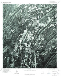
1975 Map of Helena
USGS Topo · Published 1977About this map
Helena appears during a period of transition in the mid-1970s, shown through this orthophotograph produced by the Geological Survey in cooperation with the Soil Conservation Service. The imagery follows the serpentine path of the Cahaba River, which winds through the ridges of Shelby County. Unlike traditional line-drawn maps, this aerial perspective reveals the exact footprint of residential clearings, industrial sites, and the dense forest cover that characterized the area during this era. The concentration of structures around the historical center of Helena contrasts with the surrounding topography, documenting the early stages of suburban expansion and land use patterns before the intensive development of later decades.
Find a feature on this map
2 named features on this map. Tap any name to fly to it.
Don’t see what you’re looking for? This feature index may not catch every label — zoom into the map to look around manually.
Map Details
Editions of this 1975 Helena Map
This is the sole edition of this map. No revisions or reprints were ever made.
Other maps of this area

1890 · Bessemer
USGS Topo · 1:125,000

1892 · Bessemer
USGS Topo · 1:125,000

1905 · Bessemer Iron District
USGS Topo · 1:62,500

1906 · Vandiver
USGS Topo · 1:62,500

1907 · Bessemer Special
USGS Topo · 1:62,500

1908 · Vandiver
USGS Topo · 1:62,500

1909 · Columbiana
USGS Topo · 1:62,500

1910 · Montevallo
USGS Topo · 1:62,500

1911 · Columbiana
USGS Topo · 1:62,500

1953 · Birmingham
USGS Topo · 1:250,000