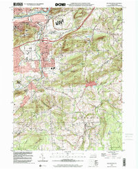
1999 Map of Hellertown
USGS Topo · Published 2001About this map
The Lehigh River corridor serves as the industrial and transportation backbone for this late-20th-century landscape, where the Lehigh Canal and Lehigh Valley RR parallel the water's edge. In the northern reaches, the city of Bethlehem and South Terrace give way to the dense street grid of Hellertown, which is flanked by the geological landmark Lost River Caverns. The transition from urban centers to the rural townships of Upper Saucon and Springfield is marked by a complex network of family and community spaces, including the Nisky Hill Cemetery and the New Jerusalem Ch.
Find a feature on this map
83 named features on this map. Tap any name to fly to it.
Don’t see what you’re looking for? This feature index may not catch every label — zoom into the map to look around manually.
Map Details
Editions of this 1999 Hellertown Map
This is the sole edition of this map. No revisions or reprints were ever made.
Other maps of this area

1888 · Quakertown
USGS Topo · 1:62,500

1890 · Easton
USGS Topo · 1:62,500

1890 · Doylestown
USGS Topo · 1:62,500

1890 · Quakertown
USGS Topo · 1:62,500

1891 · Easton
USGS Topo · 1:62,500

1891 · Doylestown
USGS Topo · 1:62,500

1894 · Allentown
USGS Topo · 1:62,500

1894 · Quakertown
USGS Topo · 1:62,500

1932 · Easton
USGS Topo · 1:62,500

1939 · Allentown
USGS Topo · 1:62,500
Featured Places
- Bethlehem, PA
- Lower Saucon Township, PA
- Durham Township, PA
- Haycock Township, PA
- Specktown, Lower Saucon Township