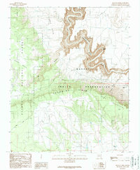
1989 Map of Hellhole Bend
USGS Topo · Published 1989About this map
Hellhole Bend serves as the dramatic centerpiece of this Coconino County terrain, where the Little Colorado River carves a deep Gorge through the desert floor. The landscape is defined by its jurisdictional and geological boundaries, with the Navajo Indian Reservation occupying the eastern portion while the Kaibab National Forest covers the west. This 1989 field-checked survey highlights the stark transition from the Lower Basin and Upper Basin to the elevated Coconino Rim.
Find a feature on this map
16 named features on this map. Tap any name to fly to it.
Don’t see what you’re looking for? This feature index may not catch every label — zoom into the map to look around manually.
Map Details
Editions of this 1989 Hellhole Bend Map
This is the sole edition of this map. No revisions or reprints were ever made.
Other maps of this area

1886 · San Francisco Mtns
USGS Topo · 1:250,000

1886 · Echo Cliffs
USGS Topo · 1:250,000

1891 · San Francisco Mtns
USGS Topo · 1:250,000

1891 · Echo Cliffs
USGS Topo · 1:250,000

1894 · San Francisco Mtns
USGS Topo · 1:250,000

1899 · San Francisco Mtns
USGS Topo · 1:250,000

1907 · Vishnu
USGS Topo · 1:48,000

1947 · Flagstaff
USGS Topo · 1:250,000

1954 · Flagstaff
USGS Topo · 1:250,000

1955 · Coconino Pt SE
USGS Topo · 1:24,000