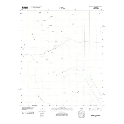
2010 Map of Hembrillo Canyon
USGS Topo · Published 2010About this map
Hembrillo Canyon cuts through the high desert of Doña Ana County, revealing a landscape defined by isolated ranching operations and early 20th-century mining claims. The presence of the Pioneer Mine, Greenback Mine, and Pioneer Jr Mine in the northern reaches suggests a period of active mineral exploration across the slopes of Grandview Mountain and Treasure Mountain. Water management is central to this arid environment, evidenced by the scattered development of Stone Spring, Mountain Sheep Spring, and Hospital Spring, alongside the Ritch Windmill. These improvements supported local cattle operations like the Ritch Ranch, while terrain features such as Ritch Rim and Victorio Canyon provide a detailed look at the challenging topography that shaped the settlement patterns of this New Mexico territory.
Find a feature on this map
30 named features on this map. Tap any name to fly to it.
Don’t see what you’re looking for? This feature index may not catch every label — zoom into the map to look around manually.
Map Details
Editions of this 2010 Hembrillo Canyon Map
This is the sole edition of this map. No revisions or reprints were ever made.
Other maps of this area
1916 · Tonuco
USGS Topo · 1:125,000
1916 · Salinas Peak
USGS Topo · 1:125,000
1916 · Tularosa
USGS Topo · 1:125,000
1916 · Point Of Sands
USGS Topo · 1:125,000
1932 · Tonuco
USGS Topo · 1:125,000
1947 · Point Of Sands 2
USGS Topo · 1:62,500
1948 · Kaylor Mountain
USGS Topo · 1:62,500
1948 · Black Top Mountain
USGS Topo · 1:62,500
1948 · Lumley Lake
USGS Topo · 1:62,500

1954 · Tularosa
USGS Topo · 1:250,000