1943 Map of Hemet
USGS Topo · Published 1943About this map
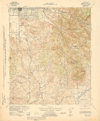
Hemet and the San Jacinto Valley are shown here during the early 1940s, revealing a landscape of developed agricultural plots contrasting with the high peaks of the San Bernardino National Forest. The map documents early educational centers such as Little Lake Sch and San Ignacio Sch, alongside rural outposts like Valle Vista and Tripp Flats. Resource extraction and forest management are evident through the Williamson Mine and the Red Mtn Lookout, while the southern portion of the sheet is defined by the Coahuila Indian Reservation. The intricate drainage system of the San Jacinto River and Bautista Creek underscores the importance of water management in this high-desert and mountain environment, with family-named landmarks like Polly Butte and Mica Butte anchoring the local topography.
Find a feature on this map
43 named features on this map. Tap any name to fly to it.
Don’t see what you’re looking for? This feature index may not catch every label — zoom into the map to look around manually.
Map Details
Editions of this 1943 Hemet Map
This is the sole edition of this map. No revisions or reprints were ever made.
Other maps of this area

1901 · Southern California Sheet No. 1
USGS Topo · 1:250,000

1901 · San Jacinto
USGS Topo · 1:125,000

1901 · Elsinore
USGS Topo · 1:125,000

1901 · San Luis Rey
USGS Topo · 1:125,000

1903 · Ramona
USGS Topo · 1:125,000

1904 · Southern California Sheet No. 2
USGS Topo · 1:250,000

1904 · Southern California Sheet No. 1
USGS Topo · 1:250,000

1939 · Warner Springs
USGS Topo · 1:62,500

1939 · Palomar Mountain
USGS Topo · 1:62,500

1940 · Palm Springs
USGS Topo · 1:62,500