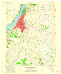
1959 Map of Henderson
USGS Topo · Published 1960About this map
The Ohio River bank serves as the commercial and industrial anchor for Henderson, Kentucky, as shown in this late 1950s revision. The city's growth is evident in its educational and civic infrastructure, featuring institutions like Douglas High Sch, Alves Street Sch, and the Audubon Sch. Near the river, Audubon Mill Park and the central Courthouse district highlight the urban core, while the extensive Waterworks and several power plants along the shore point to the mid-century industrial expansion.
Find a feature on this map
54 named features on this map. Tap any name to fly to it.
Don’t see what you’re looking for? This feature index may not catch every label — zoom into the map to look around manually.
Map Details
Editions of this 1959 Henderson Map
This is the sole edition of this map. No revisions or reprints were ever made.
Other maps of this area

1905 · Newburg
USGS Topo · 1:62,500

1906 · Sebree
USGS Topo · 1:62,500

1908 · Calhoun
USGS Topo · 1:62,500

1914 · Henderson
USGS Topo · 1:48,000

1916 · Henderson
USGS Topo · 1:62,500

1949 · Poole
USGS Topo · 1:24,000

1949 · Robards
USGS Topo · 1:24,000

1951 · Poole
USGS Topo · 1:24,000

1951 · Robards
USGS Topo · 1:24,000

1951 · Spottsville
USGS Topo · 1:24,000