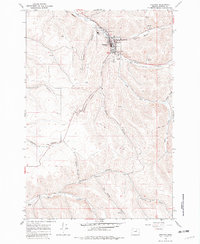
1968 Map of Heppner
USGS Topo · Published 1982About this map
Heppner serves as the focal point of this North Central Oregon landscape, situated at the confluence of Willow Creek and Hinton Creek. In the late 1960s, the town functioned as a critical agricultural and administrative hub, evidenced by the clustered Grain Elevators, the local Courthouse, and the Union Pacific railroad line threading through the canyon floor. The community infrastructure is well-documented, featuring the Pioneer Hospital, the High Sch, and the Masonic Cem on the southern slopes. Beyond the town center, the terrain is defined by a dense network of steep drainages with unique local names like Six Dollar Canyon, Sanford Canyon, and Clarks Canyon. This survey captures the rural economy of Morrow County just before the 1970s, showing a transition from traditional rail-dependent industry to modern infrastructure like the Landing Strip and Radio Tower.
Find a feature on this map
33 named features on this map. Tap any name to fly to it.
Don’t see what you’re looking for? This feature index may not catch every label — zoom into the map to look around manually.
Map Details
Editions of this 1968 Heppner Map
2 editions found
Other maps of this area

1953 · Pendleton
USGS Topo · 1:250,000

1956 · Pendleton
USGS Topo · 1:250,000

1968 · Swaggart Buttes
USGS Topo · 1:24,000

1968 · Lexington
USGS Topo · 1:24,000

1968 · Ruggs
USGS Topo · 1:24,000

1968 · Gleason Butte
USGS Topo · 1:24,000

1968 · Heppner
USGS Topo · 1:24,000

1968 · Skinners Fork
USGS Topo · 1:24,000

1969 · Summerfield Ridge
USGS Topo · 1:24,000

1969 · Hardman
USGS Topo · 1:24,000