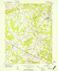
1951 Map of Herndon
USGS Topo · Published 1952About this map
The Washington and Old Dominion railroad corridor anchors this mid-century portrait of Northern Virginia, passing directly through Herndon and connecting smaller hubs like Coral and Cooktown. The landscape reflects a mix of traditional agriculture and emerging federal presence, notably at the National Bureau of Standards site and the Radio Range Sta near Willard. While the area is heavily drained by waterways such as Horsepen Run and Cub Run, the road network is already defining future growth patterns.
Find a feature on this map
44 named features on this map. Tap any name to fly to it.
Don’t see what you’re looking for? This feature index may not catch every label — zoom into the map to look around manually.
Map Details
Editions of this 1951 Herndon Map
This is the sole edition of this map. No revisions or reprints were ever made.
Other maps of this area

1884 · Harpers Ferry
USGS Topo · 1:125,000

1890 · Mt. Vernon
USGS Topo · 1:125,000

1891 · Harpers Ferry
USGS Topo · 1:125,000

1891 · Mt. Vernon
USGS Topo · 1:125,000

1893 · Frederick
USGS Topo · 1:125,000

1893 · Harpers Ferry
USGS Topo · 1:125,000

1894 · Warrenton
USGS Topo · 1:125,000

1894 · Frederick
USGS Topo · 1:125,000

1894 · Mt. Vernon
USGS Topo · 1:125,000

1897 · Mt. Vernon
USGS Topo · 1:125,000