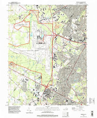
1994 Map of Herndon
USGS Topo · Published 1998About this map
Dulles International Airport dominates the central landscape of this Northern Virginia corridor, illustrating the massive scale of 1990s aviation infrastructure alongside rapidly expanding suburban developments. The map reveals a transition from traditional rural clusters like Cooktown and Schneider Crossroads to dense residential networks in Herndon and Chantilly. Significant preservation of public space is evident through the numerous stream valley parks protecting waterways like Horsepen Run and Flatlick Branch, while the W & O D Trail marks the path of former rail commerce converted for modern transit. Local heritage remains visible at the Chestnut Grove Cem and Frying Pan Park, contrasting with the high-tech presence of the National Weather Service Sterling Research and Developement Center near the Loudoun and Fairfax county line.
Find a feature on this map
70 named features on this map. Tap any name to fly to it.
Don’t see what you’re looking for? This feature index may not catch every label — zoom into the map to look around manually.
Map Details
Editions of this 1994 Herndon Map
This is the sole edition of this map. No revisions or reprints were ever made.
Other maps of this area

1884 · Harpers Ferry
USGS Topo · 1:125,000

1890 · Mt. Vernon
USGS Topo · 1:125,000

1891 · Harpers Ferry
USGS Topo · 1:125,000

1891 · Mt. Vernon
USGS Topo · 1:125,000

1893 · Frederick
USGS Topo · 1:125,000

1893 · Harpers Ferry
USGS Topo · 1:125,000

1894 · Warrenton
USGS Topo · 1:125,000

1894 · Frederick
USGS Topo · 1:125,000

1894 · Mt. Vernon
USGS Topo · 1:125,000

1897 · Mt. Vernon
USGS Topo · 1:125,000