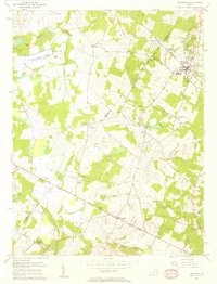
1956 Map of Herndon
USGS Topo · Published 1958About this map
Herndon and Chantilly anchor this mid-century portrait of western Fairfax and eastern Loudoun counties, showing a landscape on the cusp of significant transition. The area is characterized by traditional small settlements and rural crossroads like Floris, Navy, and Pleasant Valley, many of which grew around institutions like Frying Pan Ch and the Oak Grove Sch. Near the Loudoun and Fairfax line, the National Bureau of Standards Sterling Radio Laboratory represents the era's technological footprint, complemented by the Radio Range Station and various pipelines. Extensive stream networks, including Cub Run, Horsepen Run, and Broad Run, define the topography and historical drainage patterns. Local residential developments like Fairwood Estates and Herndon Heights begin to appear alongside established features like Chestnut Grove Cem, marking the early shifts in land use that would eventually reshape this northern Virginia corridor.
Find a feature on this map
60 named features on this map. Tap any name to fly to it.
Don’t see what you’re looking for? This feature index may not catch every label — zoom into the map to look around manually.
Map Details
Editions of this 1956 Herndon Map
2 editions found
Other maps of this area

1884 · Harpers Ferry
USGS Topo · 1:125,000

1890 · Mt. Vernon
USGS Topo · 1:125,000

1891 · Harpers Ferry
USGS Topo · 1:125,000

1891 · Mt. Vernon
USGS Topo · 1:125,000

1893 · Frederick
USGS Topo · 1:125,000

1893 · Harpers Ferry
USGS Topo · 1:125,000

1894 · Warrenton
USGS Topo · 1:125,000

1894 · Frederick
USGS Topo · 1:125,000

1894 · Mt. Vernon
USGS Topo · 1:125,000

1897 · Mt. Vernon
USGS Topo · 1:125,000