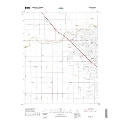
2018 Map of Herndon
USGS Topo · Published 2018About this map
The San Joaquin River forms a natural boundary between Madera and Fresno counties, snaking through the San Joaquin Central Valley. This landscape is defined by an intricate network of irrigation infrastructure essential to the region's agricultural identity. Major arteries like the Herndon Canal and Kennedy-Owens Canal are supplemented by smaller local features such as Austin Ditch, Tracy Ditch, and the Epstein Canal.
Find a feature on this map
62 named features on this map. Tap any name to fly to it.
Don’t see what you’re looking for? This feature index may not catch every label — zoom into the map to look around manually.
Map Details
Editions of this 2018 Herndon Map
This is the sole edition of this map. No revisions or reprints were ever made.
Other maps of this area

1921 · Bullard
USGS Topo · 1:31,680

1922 · Lanes Bridge
USGS Topo · 1:31,680

1922 · Gregg
USGS Topo · 1:31,680

1922 · Madera
USGS Topo · 1:31,680

1923 · Kearney Park
USGS Topo · 1:31,680

1923 · Herndon
USGS Topo · 1:31,680

1923 · Fresno
USGS Topo · 1:31,680

1923 · Biola
USGS Topo · 1:31,680

1923 · Bullard
USGS Topo · 1:31,680
1946 · Fresno South
USGS Topo · 1:24,000