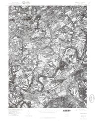
1977 Map of Hershey
USGS Topo · Published 1979About this map
Hummelstown and Hershey anchor the southern reaches of this landscape, where the winding path of Swatara Creek snakes through the central terrain. The orthophotographic imagery, derived from an April 1977 aerial survey, provides a stark visual record of the region's mid-century expansion. While the core of Hershey shows a dense grid of development, the surrounding areas like Union Deposit and Hockersville maintain a distinct agricultural character, with large field patterns punctuated by small residential clusters. To the north, the residential layout of Skyline View illustrates the suburban transition occurring at the time. The map captures a moment when the natural meanders of the creek remained the primary geographic boundary between established boroughs and the emerging residential developments of Dauphin County.
Find a feature on this map
6 named features on this map. Tap any name to fly to it.
Don’t see what you’re looking for? This feature index may not catch every label — zoom into the map to look around manually.
Map Details
Editions of this 1977 Hershey Map
This is the sole edition of this map. No revisions or reprints were ever made.
Other maps of this area

1892 · Hummelstown
USGS Topo · 1:62,500

1892 · Harrisburg
USGS Topo · 1:62,500

1899 · Harrisburg
USGS Topo · 1:62,500

1906 · New Cumberland
USGS Topo · 1:62,500

1908 · Middletown
USGS Topo · 1:62,500

1924 · Hummelstown
USGS Topo · 1:62,500

1924 · Harrisburg
USGS Topo · 1:62,500

1943 · New Cumberland
USGS Topo · 1:62,500

1943 · Middletown
USGS Topo · 1:62,500

1943 · Harrisburg
USGS Topo · 1:62,500
Featured Places
- Hershey, Derry Township
- Rutherford, Swatara Township
- Skyline View, West Hanover Township
- Hummelstown, PA
- East Hanover Township, PA