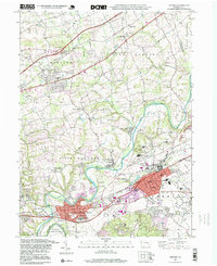
1995 Map of Hershey
USGS Topo · Published 1999About this map
Swatara Creek and the historic path of the Union Canal anchor this landscape, reflecting the long-standing water-based infrastructure that preceded the region's industrial growth. By the late 1990s, the area demonstrates a dense layering of institutional and community life, from the sprawling Hershey Medical Center and the State Police Academy to several family-named landmarks like Fishburns Cem. The map reveals the intricate development of Hershey and Hummelstown, where modern features like the Stadium and Hershey Museum sit alongside natural wonders such as Indian Echo Caverns. Throughout East Hanover and South Hanover, numerous country churches like Shells Ch and Calvary Ch provide clear touchpoints for genealogists tracing the established settlements of Sand Beach, Union Deposit, and Shellsville.
Find a feature on this map
58 named features on this map. Tap any name to fly to it.
Don’t see what you’re looking for? This feature index may not catch every label — zoom into the map to look around manually.
Map Details
Editions of this 1995 Hershey Map
This is the sole edition of this map. No revisions or reprints were ever made.
Other maps of this area

1892 · Hummelstown
USGS Topo · 1:62,500

1892 · Harrisburg
USGS Topo · 1:62,500

1899 · Harrisburg
USGS Topo · 1:62,500

1906 · New Cumberland
USGS Topo · 1:62,500

1908 · Middletown
USGS Topo · 1:62,500

1924 · Hummelstown
USGS Topo · 1:62,500

1924 · Harrisburg
USGS Topo · 1:62,500

1943 · New Cumberland
USGS Topo · 1:62,500

1943 · Middletown
USGS Topo · 1:62,500

1943 · Harrisburg
USGS Topo · 1:62,500
Featured Places
- Hershey, Derry Township
- Rutherford, Swatara Township
- Skyline View, West Hanover Township
- Hummelstown, PA
- East Hanover Township, PA