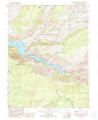
1990 Map of Hetch Hetchy Reservoir
USGS Topo · Published 1990About this map
The Tuolumne River dominates this high-country landscape, transformed by the massive Hetch Hetchy Reservoir which fills the valley floor within Yosemite National Park. This 1990 provisional map documents the rugged interior of the Yosemite Wilderness, where the Grand Canyon of the Tuolumne River cuts a deep path through granite formations. The survey detail highlights an intricate network of Pack Trails that provided the only access to remote landmarks like Le Conte Point and Smith Peak. To the south, the terrain descends toward the Middle Tuolumne River, passing smaller water bodies such as Harden Lake and Smith Meadow. The map illustrates the 20th-century management of this vital watershed, including infrastructure like the Sewage Disposal Pond tucked near the riverbanks below the reservoir's elevation.
Find a feature on this map
24 named features on this map. Tap any name to fly to it.
Don’t see what you’re looking for? This feature index may not catch every label — zoom into the map to look around manually.
Map Details
Editions of this 1990 Hetch Hetchy Reservoir Map
This is the sole edition of this map. No revisions or reprints were ever made.
Other maps of this area

1896 · Dardanelles
USGS Topo · 1:125,000

1897 · Yosemite
USGS Topo · 1:125,000

1898 · Dardanelles
USGS Topo · 1:125,000

1900 · Yosemite
USGS Topo · 1:125,000

1903 · Yosemite
USGS Topo · 1:125,000

1909 · Yosemite
USGS Topo · 1:125,000

1947 · Mariposa
USGS Topo · 1:250,000

1948 · Walker Lake
USGS Topo · 1:250,000

1948 · Mariposa
USGS Topo · 1:250,000

1956 · Pinecrest
USGS Topo · 1:62,500