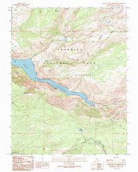
1992 Map of Hetch Hetchy Reservoir
USGS Topo · Published 1995About this map
Hetch Hetchy Reservoir dominates this 1990s-era topographic survey, illustrating the managed water landscape of Yosemite National Park. The map documents the dramatic transition from the high-elevation peaks like Mount Gibson and Smith Peak down into the Grand Canyon of the Tuolumne. The presence of the Wilderness Boundary and the Yosemite Wilderness designation reflects modern federal land management and conservation efforts during this period.
Find a feature on this map
26 named features on this map. Tap any name to fly to it.
Don’t see what you’re looking for? This feature index may not catch every label — zoom into the map to look around manually.
Map Details
Editions of this 1992 Hetch Hetchy Reservoir Map
This is the sole edition of this map. No revisions or reprints were ever made.
Other maps of this area

1896 · Dardanelles
USGS Topo · 1:125,000

1897 · Yosemite
USGS Topo · 1:125,000

1898 · Dardanelles
USGS Topo · 1:125,000

1900 · Yosemite
USGS Topo · 1:125,000

1903 · Yosemite
USGS Topo · 1:125,000

1909 · Yosemite
USGS Topo · 1:125,000

1947 · Mariposa
USGS Topo · 1:250,000

1948 · Walker Lake
USGS Topo · 1:250,000

1948 · Mariposa
USGS Topo · 1:250,000

1956 · Pinecrest
USGS Topo · 1:62,500