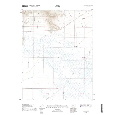
2019 Map of Hickey Bridge
USGS Topo · Published 2019About this map
The northern reaches of the San Luis Valley are defined by an intricate network of waterways and irrigation infrastructure, as shown in this 2019 survey of Saguache County. The landscape is split between the elevated McIntyre Ridge to the north and the low-lying wetlands fed by Saguache Cr and its northern branch. Human engineering is visible through long-standing water management features like the Taylor Ashley Ditch and the Rio Grande Canal, which traverse the flat valley floor to support local agriculture. The eponymous Hickey Bridge provides a vital crossing point over the N Br Saguache Cr amidst a grid of county roads. These labeled channels and named gulches, such as De Tilla Gulch and Proffit Gulch, reveal the historical reliance on water diversion in this high-altitude basin.
Find a feature on this map
35 named features on this map. Tap any name to fly to it.
Don’t see what you’re looking for? This feature index may not catch every label — zoom into the map to look around manually.
Map Details
Editions of this 2019 Hickey Bridge Map
This is the sole edition of this map. No revisions or reprints were ever made.
Other maps of this area

1915 · Del Norte
USGS Topo · 1:125,000

1917 · Del Norte
USGS Topo · 1:125,000

1945 · Durango
USGS Topo · 1:250,000

1953 · Durango
USGS Topo · 1:250,000

1954 · Durango
USGS Topo · 1:250,000

1954 · Trinidad
USGS Topo · 1:250,000

1954 · Pueblo
USGS Topo · 1:250,000

1955 · Trinidad
USGS Topo · 1:250,000

1956 · Montrose
USGS Topo · 1:250,000

1957 · Pueblo
USGS Topo · 1:250,000