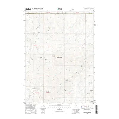
2014 Map of Hicks Mountain
USGS Topo · Published 2014About this map
The Humboldt National Forest encompasses this high-elevation landscape in northeastern Nevada, where the border of Elko County meets Owyhee County at the Idaho-Nevada line. Central to the map is the prominent Hicks Mountain and the Bruneau Range, areas defined by deep drainage networks including Hicks Creek and Salmon Creek. The landscape preserves local nomenclature through features like Yankee Bill Flat, Yankee Bill Gulch, and Yankee Bill Summit, hinting at the region's ranching or prospecting history. Navigational access is limited to primitive forest routes such as National Forest Development Road 023, which winds through Sagehen Basin and past Salmon Meadow. Further south, the terrain descends toward The Mahoganies and Robinson Canyon, illustrating a transition from timbered heights to the rugged draws of the Great Basin.
Find a feature on this map
62 named features on this map. Tap any name to fly to it.
Don’t see what you’re looking for? This feature index may not catch every label — zoom into the map to look around manually.
Map Details
Editions of this 2014 Hicks Mountain Map
This is the sole edition of this map. No revisions or reprints were ever made.
Other maps of this area
1936 · Mountain City
USGS Topo · 1:62,500
1936 · Rowland
USGS Topo · 1:48,000
1940 · Rowland
USGS Topo · 1:62,500
1940 · Mountain City
USGS Topo · 1:62,500

1955 · Twin Falls
USGS Topo · 1:250,000

1955 · Wells
USGS Topo · 1:250,000

1958 · Wells
USGS Topo · 1:250,000

1958 · Twin Falls
USGS Topo · 1:250,000

1961 · Wells
USGS Topo · 1:250,000
1979 · Indian Hay Meadows
USGS Topo · 1:24,000