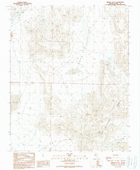
1989 Map of Hidden Valley
USGS Topo · Published 1990About this map
The McCullough Range dominates the eastern and southern reaches of this Mojave Desert landscape, casting a rain shadow over the arid expanse of Hidden Valley. This late-twentieth-century survey documents a region defined by its lack of standing water, centered on the ephemeral Dry Lake and the northern tip of Jean Lake. Human activity in this basin is primarily industrial and extractive, evidenced by several resource sites including a Quarry, Sandpits, and a Gravel Pit.
Find a feature on this map
17 named features on this map. Tap any name to fly to it.
Don’t see what you’re looking for? This feature index may not catch every label — zoom into the map to look around manually.
Map Details
Editions of this 1989 Hidden Valley Map
This is the sole edition of this map. No revisions or reprints were ever made.
Other maps of this area

1910 · Ivanpah
USGS Topo · 1:250,000

1912 · Ivanpah
USGS Topo · 1:250,000

1942 · Ivanpah
USGS Topo · 1:250,000

1947 · Kingman
USGS Topo · 1:250,000

1948 · Kingman
USGS Topo · 1:250,000

1954 · Kingman
USGS Topo · 1:250,000

1955 · Kingman
USGS Topo · 1:250,000

1955 · Roach Lake
USGS Topo · 1:62,500

1958 · Kingman
USGS Topo · 1:250,000

1960 · Kingman
USGS Topo · 1:250,000