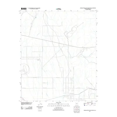
2011 Map of Hieroglyphic Mountains SW
USGS Topo · Published 2011About this map
English Camp stands as a primary point of interest in this arid landscape northwest of Peoria, where the desert is defined by a complex network of seasonal drainage channels. The geography is dominated by the southward-flowing Picacho Wash and Padelford Wash, which dictate the natural movement of water across the terrain. These natural features are overlaid by a rigid modern grid of numbered avenues and named streets that signal the encroaching development of the Phoenix metropolitan area.
Find a feature on this map
24 named features on this map. Tap any name to fly to it.
Don’t see what you’re looking for? This feature index may not catch every label — zoom into the map to look around manually.
Map Details
Editions of this 2011 Hieroglyphic Mountains SW Map
This is the sole edition of this map. No revisions or reprints were ever made.
Other maps of this area

1954 · Phoenix
USGS Topo · 1:250,000

1957 · Phoenix
USGS Topo · 1:250,000

1957 · White Tank Mts. NE
USGS Topo · 1:24,000

1957 · Calderwood Butte
USGS Topo · 1:24,000

1957 · McMicken Dam
USGS Topo · 1:24,000

1957 · White Tank Mts.
USGS Topo · 1:62,500

1958 · Phoenix
USGS Topo · 1:250,000

1960 · Phoenix
USGS Topo · 1:250,000
1964 · Garfias Mountain
USGS Topo · 1:24,000
1964 · Red Picacho
USGS Topo · 1:24,000