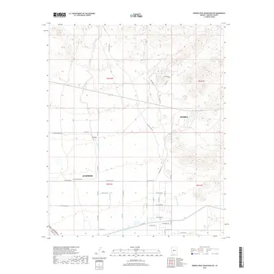
2018 Map of Hieroglyphic Mountains SW
USGS Topo · Published 2018About this map
Peoria and Surprise appear during a period of rapid suburban expansion in the northwest Phoenix valley. The landscape is characterized by the transition from open desert to organized residential development, with numerous numbered avenues like 187th Ave and 163rd Ave cutting across the desert floor. A major industrial presence is the Chrysler Corp Proving grounds, occupying a significant portion of the western terrain. The natural drainage of the region is defined by ephemeral waterways such as N Picacho Wash, Padelford Wash, and M E Wash, which contrast with the engineered path of the Central Arizona Project Aqueduct visible in the south. This 2018 survey captures the intricate grid of new residential streets like Saguaro Breeze and Iron Age Dr as they begin to fill the spaces between the Hieroglyphic Mountains and the growing urban core.
Find a feature on this map
42 named features on this map. Tap any name to fly to it.
Don’t see what you’re looking for? This feature index may not catch every label — zoom into the map to look around manually.
Map Details
Editions of this 2018 Hieroglyphic Mountains SW Map
This is the sole edition of this map. No revisions or reprints were ever made.
Other maps of this area

1954 · Phoenix
USGS Topo · 1:250,000

1957 · Phoenix
USGS Topo · 1:250,000

1957 · White Tank Mts. NE
USGS Topo · 1:24,000

1957 · Calderwood Butte
USGS Topo · 1:24,000

1957 · McMicken Dam
USGS Topo · 1:24,000

1957 · White Tank Mts.
USGS Topo · 1:62,500

1958 · Phoenix
USGS Topo · 1:250,000

1960 · Phoenix
USGS Topo · 1:250,000
1964 · Garfias Mountain
USGS Topo · 1:24,000
1964 · Red Picacho
USGS Topo · 1:24,000