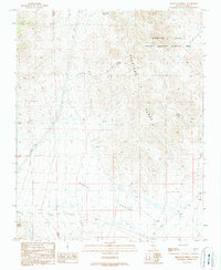
1989 Map of Highland Spring
USGS Topo · Published 1990About this map
The Highland Range rises sharply from the eastern edge of this landscape, overlooking the broad expanse of Piute Valley in Clark County. This 1989 provisional study documents a region of critical ecological management, specifically the Crucial Bighorn Habitat Area that spans the northern peaks. Human impact is sparse but visible through a network of unimproved roads and Trans Lines that skirt the alluvial fans. Water sources are the primary landmarks for navigation and land use in this arid environment, including Ora Hanna Spring, Highland Spring, and Cow Spring. Several locations marked as Guzzler indicate the presence of artificial watering holes designed to support local wildlife. A small Radio Facility and a Corral suggest isolated pockets of utility and ranching activity amidst the desert scrub and rocky slopes.
Find a feature on this map
12 named features on this map. Tap any name to fly to it.
Don’t see what you’re looking for? This feature index may not catch every label — zoom into the map to look around manually.
Map Details
Editions of this 1989 Highland Spring Map
This is the sole edition of this map. No revisions or reprints were ever made.
Other maps of this area

1886 · Camp Mohave
USGS Topo · 1:250,000

1892 · Camp Mohave
USGS Topo · 1:250,000

1910 · Ivanpah
USGS Topo · 1:250,000

1912 · Ivanpah
USGS Topo · 1:250,000

1926 · Nelson
USGS Topo · 1:96,000

1926 · Mohave City
USGS Topo · 1:96,000

1942 · Camp Mohave
USGS Topo · 1:250,000

1942 · Ivanpah
USGS Topo · 1:250,000

1947 · Kingman
USGS Topo · 1:250,000

1948 · Kingman
USGS Topo · 1:250,000