1942 Map of Hightstown
USGS Topo · Published 1942About this map
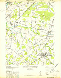
The Pennsylvania Railroad anchors this central New Jersey landscape, cutting a diagonal path through a mix of academic institutions, specialized research facilities, and agricultural estates. In the early 1940s, the area south of Kingston served as a notable hub for education and science, featuring the St Josephs College for Boys and the Rockefeller Institute for Medical Research. The borough of Hightstown sits as a primary center of population at the intersection of local roads and rail lines, characterized by the presence of the Peddie Prep Sch near the banks of Rocky Brook.
Find a feature on this map
40 named features on this map. Tap any name to fly to it.
Don’t see what you’re looking for? This feature index may not catch every label — zoom into the map to look around manually.
Map Details
Editions of this 1942 Hightstown Map
This is the sole edition of this map. No revisions or reprints were ever made.
Other maps of this area

1888 · Bordentown
USGS Topo · 1:62,500

1888 · New Brunswick
USGS Topo · 1:62,500

1888 · Princeton
USGS Topo · 1:62,500

1888 · Cassville
USGS Topo · 1:62,500

1893 · Bordentown
USGS Topo · 1:62,500

1893 · New Brunswick
USGS Topo · 1:62,500

1894 · Princeton
USGS Topo · 1:62,500

1894 · Cassville
USGS Topo · 1:62,500

1900 · Cassville
USGS Topo · 1:62,500

1901 · New Brunswick
USGS Topo · 1:62,500
Featured Places
- Franklin Township, NJ
- South Brunswick, NJ
- East Windsor Township, NJ
- West Windsor, NJ
- Plainsboro Township, NJ