1995 Map of Hightstown
USGS Topo · Published 2000About this map
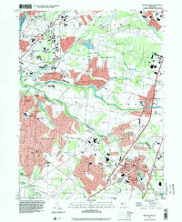
Hightstown serves as a major hub in this mid-1990s landscape, where the New Jersey Turnpike and Interchange No 8 facilitate rapid suburban expansion. Educational institutions anchor the area, including the sprawling Princeton University Forrestal Campus and the prestigious Peddie Sch overlooking Peddie Lake. The map reveals a transition from traditional centers like Cranbury and Plainsboro to burgeoning residential developments spreading across the former farmlands of West Windsor and East Windsor.
Find a feature on this map
81 named features on this map. Tap any name to fly to it.
Don’t see what you’re looking for? This feature index may not catch every label — zoom into the map to look around manually.
Map Details
Editions of this 1995 Hightstown Map
This is the sole edition of this map. No revisions or reprints were ever made.
Other maps of this area

1888 · Bordentown
USGS Topo · 1:62,500

1888 · New Brunswick
USGS Topo · 1:62,500

1888 · Princeton
USGS Topo · 1:62,500

1888 · Cassville
USGS Topo · 1:62,500

1893 · Bordentown
USGS Topo · 1:62,500

1893 · New Brunswick
USGS Topo · 1:62,500

1894 · Princeton
USGS Topo · 1:62,500

1894 · Cassville
USGS Topo · 1:62,500

1900 · Cassville
USGS Topo · 1:62,500

1901 · New Brunswick
USGS Topo · 1:62,500
Featured Places
- Franklin Township, NJ
- South Brunswick, NJ
- East Windsor Township, NJ
- West Windsor, NJ
- Plainsboro Township, NJ