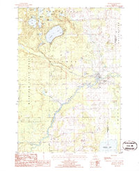
1986 Map of Hillman
USGS Topo · Published 1986About this map
The Thunder Bay River winds through the heart of this northeastern Michigan landscape, anchoring the village of Hillman. By the mid-1980s, the area reflects a balance between rural settlement and recreational geography, with the northern reaches of Fletcher Pond and numerous glacial lakes like Avalon Lake and Ess Lake defining the local environment. Within the Mackinaw State Forest, the terrain is marked by a network of creeks, including Brush Creek and Anchor Creek, alongside infrastructure like a Landing Strip and Sewage Disposal (Ponds). Evidence of local industry is visible through several Gravel Pit operations, while a Cem and Campground near the village provide points of interest for genealogists and local historians tracking the community's development and use of the land along the river's path through Hillman and Wellington townships.
Find a feature on this map
31 named features on this map. Tap any name to fly to it.
Don’t see what you’re looking for? This feature index may not catch every label — zoom into the map to look around manually.
Map Details
Editions of this 1986 Hillman Map
This is the sole edition of this map. No revisions or reprints were ever made.
Other maps of this area

1954 · Traverse City
USGS Topo · 1:250,000

1954 · Tawas City
USGS Topo · 1:250,000

1954 · Alpena
USGS Topo · 1:250,000

1955 · Atlanta
USGS Topo · 1:62,500

1955 · Comins
USGS Topo · 1:62,500

1955 · Hillman
USGS Topo · 1:62,500

1955 · Cheboygan
USGS Topo · 1:250,000

1957 · Alpena
USGS Topo · 1:250,000

1958 · Cheboygan
USGS Topo · 1:250,000

1958 · Traverse City
USGS Topo · 1:250,000