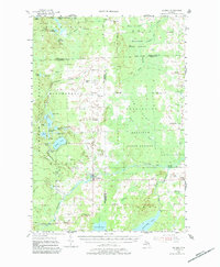
1955 Map of Hillman
USGS Topo · Published 1984About this map
Hillman and its surrounding timberlands and watersheds are captured here during the mid-1950s, a period when the village served as a primary hub for the rural corners of Montmorency, Alpena, and Presque Isle counties. The Thunder Bay River snakes through the center of the sheet, feeding into the expansive Fletcher Pond at the southern edge, while the northern reaches are dominated by the Mackinaw State Forest. This era shows a landscape still defined by decentralized education and local faith, with numerous country schools like Babcock Sch and Collins Sch dotting the township roads alongside St Johns Ch and St Augustine Cem.
Find a feature on this map
61 named features on this map. Tap any name to fly to it.
Don’t see what you’re looking for? This feature index may not catch every label — zoom into the map to look around manually.
Map Details
Editions of this 1955 Hillman Map
3 editions found
Other maps of this area

1954 · Traverse City
USGS Topo · 1:250,000

1954 · Tawas City
USGS Topo · 1:250,000

1954 · Alpena
USGS Topo · 1:250,000

1955 · Atlanta
USGS Topo · 1:62,500

1955 · Comins
USGS Topo · 1:62,500

1955 · Hillman
USGS Topo · 1:62,500

1955 · Cheboygan
USGS Topo · 1:250,000

1957 · Alpena
USGS Topo · 1:250,000

1957 · Onaway
USGS Topo · 1:62,500

1958 · Cheboygan
USGS Topo · 1:250,000