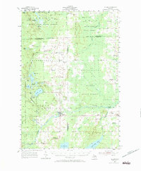
1955 Map of Hillman
USGS Topo · Published 1972About this map
Hillman serves as the central hub of this mid-century survey, situated at the confluence of the Thunder Bay River and its various tributaries. The landscape is a patchwork of state-managed lands, including the Black Lake State Forest and Alpena State Forest, reflecting the region's transition from early timber harvesting to recreational and conservation uses. The social fabric of these rural townships is clearly visible through a high density of one-room schoolhouses like Streasick Sch, Skiera Sch, and Greenwood Sch, which were often the heart of their respective sections. To the south, the massive Fletcher Pond dominates the terrain, while the presence of the Hillman Landing Field and numerous family-named gravel pits indicates the localized transport and resource extraction patterns of the era. Genealogists will find value in the specific placement of St Johns Cem and St Augustine Cem.
Find a feature on this map
72 named features on this map. Tap any name to fly to it.
Don’t see what you’re looking for? This feature index may not catch every label — zoom into the map to look around manually.
Map Details
Editions of this 1955 Hillman Map
3 editions found
Other maps of this area

1954 · Traverse City
USGS Topo · 1:250,000

1954 · Tawas City
USGS Topo · 1:250,000

1954 · Alpena
USGS Topo · 1:250,000

1955 · Atlanta
USGS Topo · 1:62,500

1955 · Comins
USGS Topo · 1:62,500

1955 · Hillman
USGS Topo · 1:62,500

1955 · Cheboygan
USGS Topo · 1:250,000

1957 · Alpena
USGS Topo · 1:250,000

1957 · Onaway
USGS Topo · 1:62,500

1958 · Cheboygan
USGS Topo · 1:250,000