
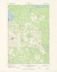
1957 Map of Onaway
USGS Topo · Published 1959About this map
Onaway serves as the primary hub of this 1950s northern Michigan landscape, situated at the intersection of several local routes just south of the Onaway State Park. The region is defined by the heavy presence of the Black Lake State Forest, which blankets much of the interior. Transportation and industry are anchored by the Detroit and Mackinac railroad, which runs through the village of Millersburg and passes several gravel pits that mark the local economy.
Find a feature on this map
64 named features on this map. Tap any name to fly to it.
Don’t see what you’re looking for? This feature index may not catch every label — zoom into the map to look around manually.
Map Details
Editions of this 1957 Onaway Map
2 editions found
Other maps of this area

1954 · Hetherton
USGS Topo · 1:62,500

1954 · Alpena
USGS Topo · 1:250,000

1955 · Atlanta
USGS Topo · 1:62,500

1955 · Hillman
USGS Topo · 1:62,500

1955 · Cheboygan
USGS Topo · 1:250,000

1957 · Alpena
USGS Topo · 1:250,000

1957 · Tower
USGS Topo · 1:62,500

1957 · Cheboygan
USGS Topo · 1:62,500

1958 · Cheboygan
USGS Topo · 1:250,000

1958 · Alpena
USGS Topo · 1:250,000