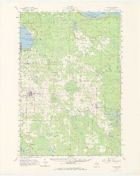
1957 Map of Onaway
USGS Topo · Published 1969About this map
Onaway and Millersburg anchor this northern Michigan landscape during the mid-1950s, a region defined by the vast Black Lake State Forest and the rugged drainage of the Ocqueoc River. The settlement pattern follows the Detroit and Mackinac rail line and the shores of Black Lake, where seasonal recreation is evidenced by Canfield Beach and Onaway State Park.
Find a feature on this map
65 named features on this map. Tap any name to fly to it.
Don’t see what you’re looking for? This feature index may not catch every label — zoom into the map to look around manually.
Map Details
Editions of this 1957 Onaway Map
2 editions found
Other maps of this area

1954 · Hetherton
USGS Topo · 1:62,500

1954 · Alpena
USGS Topo · 1:250,000

1955 · Atlanta
USGS Topo · 1:62,500

1955 · Hillman
USGS Topo · 1:62,500

1955 · Cheboygan
USGS Topo · 1:250,000

1957 · Alpena
USGS Topo · 1:250,000

1957 · Tower
USGS Topo · 1:62,500

1957 · Cheboygan
USGS Topo · 1:62,500

1957 · Onaway
USGS Topo · 1:62,500

1958 · Cheboygan
USGS Topo · 1:250,000